Ride On! Snag a Copy Of the New Chippewa Valley Bike Map
newest edition features new trails, bike shops, and route ratings for safety and comfort
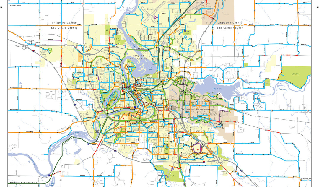
Hit scenic local bike routes this summer with a copy of the new Chippewa Valley Bike Map, courtesy of Bike Chippewa Valley.
The 2021 edition of the map features dozens of notable changes – perfect for the increase of folks looking to get hiking and biking outdoors as a result of COVID-19 – but haven’t been able to snag the last map, which was printed in 2015.
“There’s kind of a bicycle boom because of the pandemic and everyone wanting to get outside,” said Jeremy Gragert, president of Bike Chippewa Valley. “It’s nice to not have a map shortage.”
You can grab one of over 25,000 copies of the updated map at any local bike shop, Blue Ox Running, The Local Store, local libraries, and many other locations throughout the Chippewa Valley. “There’s nothing as up-to-date as this, or as detailed,” Gragert said.
And he would know, as he’s cycled through every one of the routes on the map to ensure each one is rideable, accurate, and ranked according to comfort level.
“There’s this challenge of getting to certain places or envisioning a route,” he said. “You just really need to know what you’re doing.”
Beginners can check out blue routes, which include low-traffic routes with a shoulder on the road and a bike lane. Orange routes are indicate potentially less comfortable routes, as there’s only sometimes a bike lane and generally higher traffic. Dashed red lines indicate a difficult connection between two trails – meaning there’s generally higher traffic and no shoulder to the road.
Other notable changes to the map include:
- New biking trails! The latest edition includes new bike trails, including the updated Old Abe State Trail, which now connects Eau Claire to Chippewa Falls; the Chippewa River State Trail that connects Eau Claire to Durand; and the Red Cedar State Trail that connects the Chippewa River State Trail to Menomonie.
- Expanded view. The updated map includes the Town of Seymour (including Tower Ridge recreation area) as well as Eau Claire down by Highway 29 (showing ideal places to cross the busy intersection). It also includes a close-up of Altoona – including the newly developed River Prairie.
- A more detailed key. The map’s key has been updated, including more clear symbols. The hill symbol, in particular, is more fine tuned. A single arrow designates a hill of 30ft., going uphill in the direction it points. Double arrows designate double the footage (60 ft.), etc. “Now you have a much more fine-grained idea of what you’re getting yourself into,” Gragert said.
- The inclusion of more bike shops. Since the last map’s publication in 2015, more bike shops have opened, including Stache Bike & Adventure (414 N Farwell St, Eau Claire) and SHIFT Cyclery & Coffee Bar (615 Graham Ave, Eau Claire).
- Looking to get outside of Eau Claire? No problem! The map includes what Gragert calls “escape routes,” depicting routes heading 2-3 miles outside of Eau Claire for people looking for longer, more scenic routes in areas such as Fall Creek and Elk Mound.
- QR code leads to an online version. A QR code leads to a PDF version of the map, so you can have it in clutch while you’re on the go.
- All trails are marked in green, with state trails in dark green.
Check out the updated map – and more opportunities to ride through the Valley – at bikechippewavalley.com or the Bike Chippewa Valley Facebook page at facebook.com/bikechippewavalley.
