“Where the deer at?”
lots of you probably head up north to hunt, but is that the best spot?
Maybe it’s just me, but the vast majority of my family, friends, and acquaintances who hunt tend to do so “up north.” I don’t know if it’s because they know someone with land “up there,” or if it’s become a tradition shaped by the thinking that, the further you are from dense urban areas (Milwaukee, Madison, etc.), the more deer there will be. Anyway, it got me curious about where the deer hang out in Wisconsin, and I figured the DNR might know.
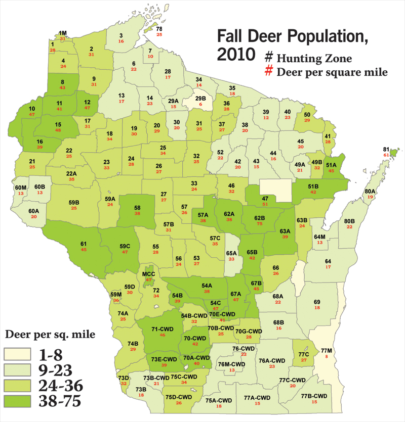
Indeed, every year the Wisconsin DNR estimates the size of the deer population. The areas in which they do so are called “deer management units” (instead of, say, by counties), and they estimate for two time periods: fall pre-hunt and overwinter post-hunt.
The density statistics take harvest numbers into account, so areas that appear to have fewer deer may actually have more, but are popular for successful hunters. The areas they estimated in 2010 varied from as few as one buck killed per square mile to as many as 12 killed per square mile. Meanwhile the populations varied from about seven deer per square mile to more than 100 per square mile.
The DNR has loads of statistics and maps (only a fraction shown here), usually expressed in the amount of deer per square mile in each area. Based on what they found, a few “trends” are apparent. The highest amount of deer in fall appear to be in the east-central and southern parts of the state, and the lowest amounts were in north-central and north-eastern Wisconsin. The range of the deer is likewise an interesting factor, as the deer in the northern part of the state appear to be far more mobile (meaning traveling from one place to another), while the deer in south Wisconsin are far more static (travel much less).
Anyway, give these a look. It may make you reconsider your hunting habits.
Visit DNR.wi.gov/org/land/wildlife/hunt/deer/maps.htm for more info.


